Satellite images show lakes ‘missing’ from HMDA database
By Sumit Jha Published on 29 Oct 2020 6:43 AM GMT
Hyderabad: On the night of 13 October, four members of a family washed away after a bund of Appa Cheruvu at Gagan Pahad developed a breach. Three of the bodies, including that of a minor, were found on the morning of 14 October near their house. The body of the boy was found on 17 October near the Gaganpahad stretch after search operations resumed in the area.
The bund of Appa Cheruvu developed a breach as it was unable to withstand the huge inflow from Brahmandla Kunta, another water body located upstream and linked to a few other water channels in the downwards direction. Dream Monarch, a gated community, also stood in that path.
Bramandla Kunta was the first to develop a breach causing a flood directly into Appa Cheruvu which was already filled due to increscent rains.
The Appa Cheruvu is not even notified as a lake by the Hyderabad Metropolitan Development Authority (HMDA) despite its discovery back in 2014 by NGO Save Our Urban Lakes (SOUL).
In 2014, when the government released data of around 3,000 lakes in the jurisdiction of HMDA, SOUL tried to compare it with a survey of India map and village map which is the official database for identifying lands. They listed around 300 lakes which were missing from the HMDA database. One of the lake was Appa Cheruvu.
“First of all, the government killed these lakes by deleting them from its database. For historical data, we use the survey of India map and the village map and it shows that the lake is still there which means that it has been encroached upon. When the government created new data on HMDA, they eliminated many of these lakes,” said Dr Lubna Sarwat of SOUL who is also the Telangana State General Secretary & Spokes Person of Socialist Party (India).
She also added that a kml file (a file format used to display geographic data), as well as a pdf file list with geo coordinates, was given to the lake protection committee of which the collector of Ranga Reddy, the GHMC, the HMDA, the Lokayukta, the irrigation minister of the state and environment minister of Telangana are members. Appa Cheruvu lake was one of those lakes identified in that file.
“We have been urging in numerous representations to restore lakes and the interlinked channels of the lakes to ensure the free flow of surplus waters from one lake to another after the lake is filled to its maximum water spread and to its original storage capacity, from which they finally drain into Musi River, but it all went in vain,” she said.
She said how during the Kakatiya dynasty, several water bodies were interconnected as part of water conservation and flood prevention system and the water flowed downstream into the Musi river. The loss of life in this flood is because of the hydrological network that is not notified by the HMDA and subsequently not protected/restored by officials and by elected leaders of the area. “People faced the loss of life and property and severe problems due to the lakes not being restored and in spite of repeated orders from the high court and the Supreme Court to take care of water bodies,” said Lubna Sarwat. She said that no care was taken in spite of the High Court asking for the condition of all lakes in one of the PILs filed for the restoration of Khajaguda Pedda Cheruvu.
Below is the historical satellite imagery from Google Earth of both upstream Brahman Kunta, Gaganpahad and Appa Cheruvu, Gaganpahad to understand how officials and elected leaders presided over the destruction of water bodies and brought misery on citizens:
Picture 1: Comparative Satellite Imageries of Brahaman Kunta and Appa Cheruvu in 2017-18 and 2020.
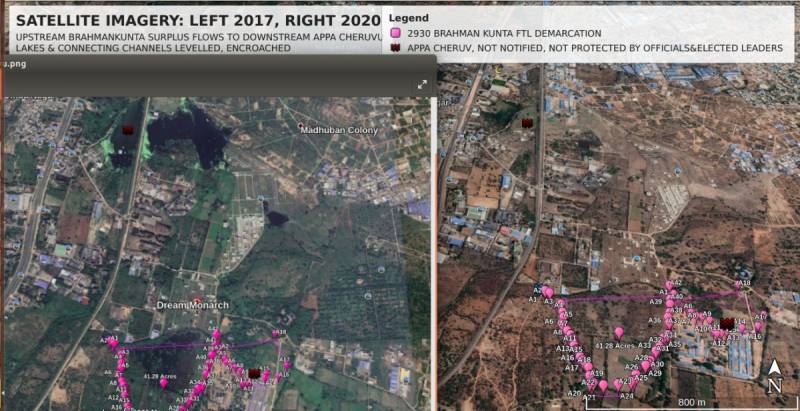
The left side is the imagery from November 2017 and the right side is satellite imagery of the same area from May 2020.
The images show how when lakes are encroached upon and connecting channels, that are needed to drain out excess waters are destroyed, then the rainwater has nowhere to go but overflow into habitations.
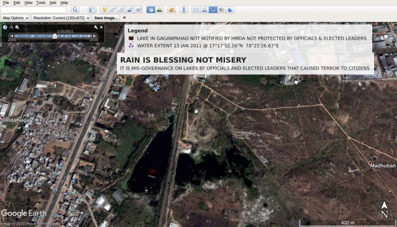
Picture 2: 15 January 2011 satellite imagery of Appa Cheruvu filled with water.
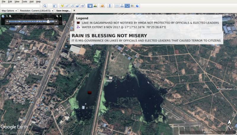
Picture 3: 9 November 2017 satellite imagery of Appa Cheruvu filled with water.
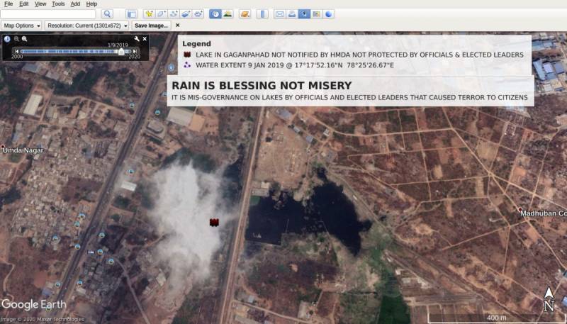
Picture 4: 9 January 2019 satellite imagery of Appa Cheruvu still has water in spite of not much of rains.
Picture 5: 26 November 2019 satellite imagery of Appa Cheruvu which by then was landfilled.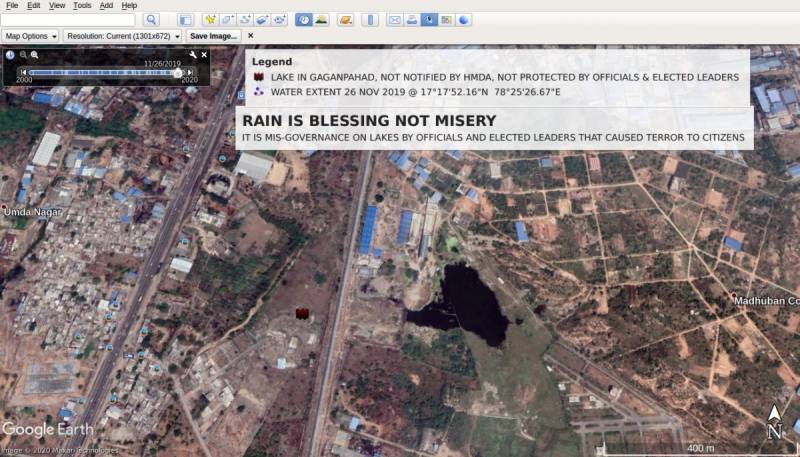
Picture 6: 29 May 2020 satellite imagery of Appa Cheruvu
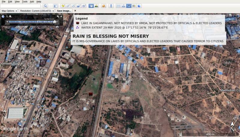
Satellite imageries sourced from Lubna Sarwat/Save Our Urban Lakes