Satellite imagery captures how Surram Cheruvu in Bandalguda shrank in four years
As per the information on the Hyderabad Metropolitan Development Authority (HMDA) website, preliminary notification that provided the FTL demarcation for Surram Cheruvu was done on 12 December 2016. But the final notification was not uploaded to date.
By Sumit Jha Published on 6 Nov 2020 5:15 AM GMT
Hyderabad: Between 12 and 18 October, Hyderabad received unprecedented rainfall which led to more than 50 deaths and property loss of Rs 670 crore within the city limits.
At various places, lakes reclaimed their lost ground and drowned the area in their sprawl. Surram Cheruvu in Bandalguda was one such lake that breached its full tank level (FTL) and engulfed the surrounding area during the unprecedented rain.
As per the information on the Hyderabad Metropolitan Development Authority (HMDA) website, preliminary notification that provided the FTL demarcation for Surram Cheruvu was done on 12 December 2016. But the final notification was not uploaded to date.
The Hyderabad district collector had stated in his letter to the HMDA in January 2017 that the final notification maps have already been submitted to the HMDA for them to act as required.
"The lake protection committee, of which HMDA Commissioner is the chairman, failed to submit the final notification, even after receiving the final notification maps four years ago. The HMDA had stated in August 2016 that the final verification is due from their end. But nothing has been done so far," said Lubna Sarwat from the Save Our Urban Lakes (SOUL) group and the state general secretary for the Socialist Party (India).
According to Lubna Sarwat, a notification from the Hyderabad Urban Development Authority (HUDA) in 2000 said that Suram Cheruvu was measured as 19.80 hectares (46.95 acres). But the HMDA preliminary notified map showed Suram Cheruvu area at 39.302 acres. HUDA was merged with the HMDA later on.
The HUDA notification said that, "All local bodies, municipalities and gram panchayats, under whose jurisdiction these lakes fall, are hereby directed to take steps to exercise utmost vigilance to prevent any type of encroachments, reclamation, petition or damage of any type to the lakes listed in this notification." The notification also directed the administrative bodies to not give permission of any kind to buildings or structures of any type within the FTL and within the 30-metre buffer belt around the lakes under any circumstances.
"The online and field survey of the Surram Cheruvu indicated that the authorities concerned have not implemented any of these guidelines or the court orders," said Lubna Sarwat.
Lubna Sarwat alleged that on 15 and 16 July 2020 they had a detailed conversation with the GHMC planning officials regarding building permissions given by the GHMC for constructions at Bandlaguda that fall inside the FTL of Surram Cheruvu. "We are yet to receive answers," added Lubna.
A field survey by Lubna Sarwat revealed major high rises and constructions inside the FTL boundary of Surram Cheruvu.
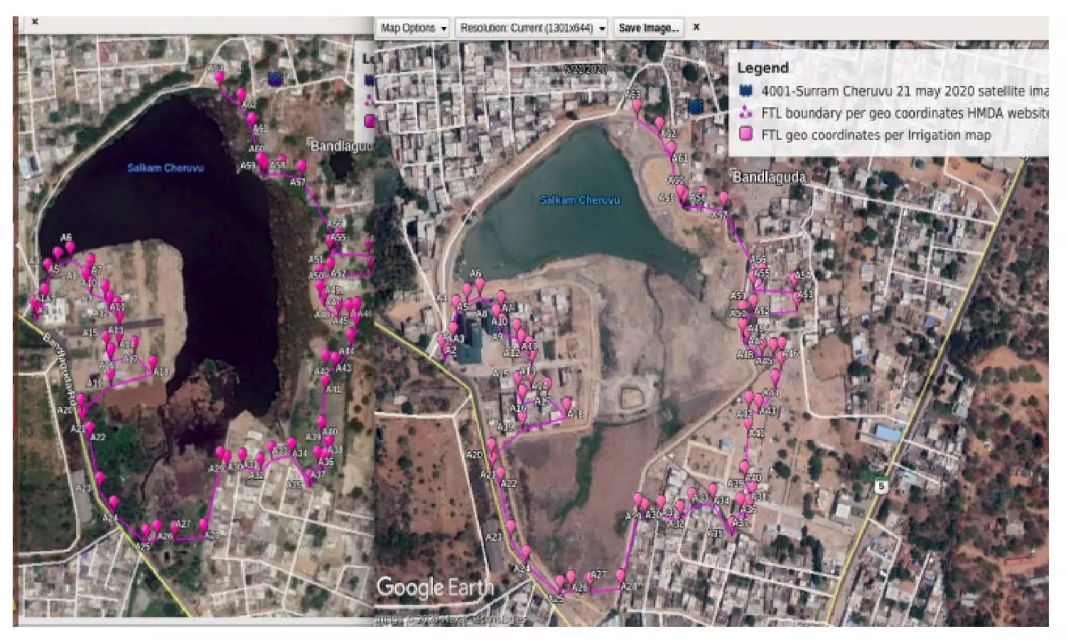
Through satellite imagery the encroachment of the Surram Cheruvu is evident. Below is comparative imagery from 2016 and 2020 obtained from Google Earth:
Picture 5: Satellite imagery from Google Earth dated 21 May 2020 (right side of image), when compared with the satellite imagery from 27 May 2016 (left side of the image), makes the massive constructions and encroachments self-explanatory. The pink line indicates the official FTL boundary as per HMDA geo coordinates.
Below is satellite imagery of the Surram Cheruvu from 1 November 2017 when the city received heavy rains.
Picture 6: Surram Cheruvu identified on NRSC Bhuvan2D at https://bhuvan.nrsc.gov.in/
Picture 7: Satellite imagery from NRSC Bhuvan2D @ https://bhuvan.nrsc.gov.in/bhuvan_links.php
Picture 8: Salkam Cheruvu in SOI toposheet renamed and notified as 4001 Suram Cheruvu by HMDA with its hydrology
Picture 9: Gravel deposits and concrete works inside layout in FTL of lake, shot @ 17° 18' 35.58" N, 78° 28' 19.09" E
Lubna also alleged that contrary to all rules and stated objective and mandate of the lake protection committee and the Hyderabad District Walta authority, Bandlaguda Mandal WALTA authority, and state WALTA authority constituted under Walta Act 2002 and WALTA Rules 2004, the lake has been trespassed upon with constructions, landfills and pollution.
"Powers have been given to authorities to promote water conservation, and tree cover and regulate the exploitation and use of ground and surface water for the protection and conservation of water sources, land and environment and matters connected therewith or incidental thereto Act No. 10 of 2002 Water, Land and Trees Act (Walta), 2002 and Rules 2004," said Lubna
Section 23 of the Act is below.
Picture 9: Extract of sec 23 of WALTA Act 2002
Implementation of the Section 23 (1) of WALTA Act 2002 entails the authorities to 'power to prevent and remove encroachments into the demarcated area of the water body', she said. There is a strict prohibition of construction of any sort within the FTL boundaries, as well as any activities in the buffer zone of channels and water bodies, save some exceptions.
Lubna Sarwat has filed a petition in Telangana High Court demanding the removal of high rises, buildings, constructions in the FTL and buffer zone boundary.
"We appeal for restoration of the lake and its hydrology. We appeal for participative and transparent governance of the Surram Cheruvu to be established," she added.
