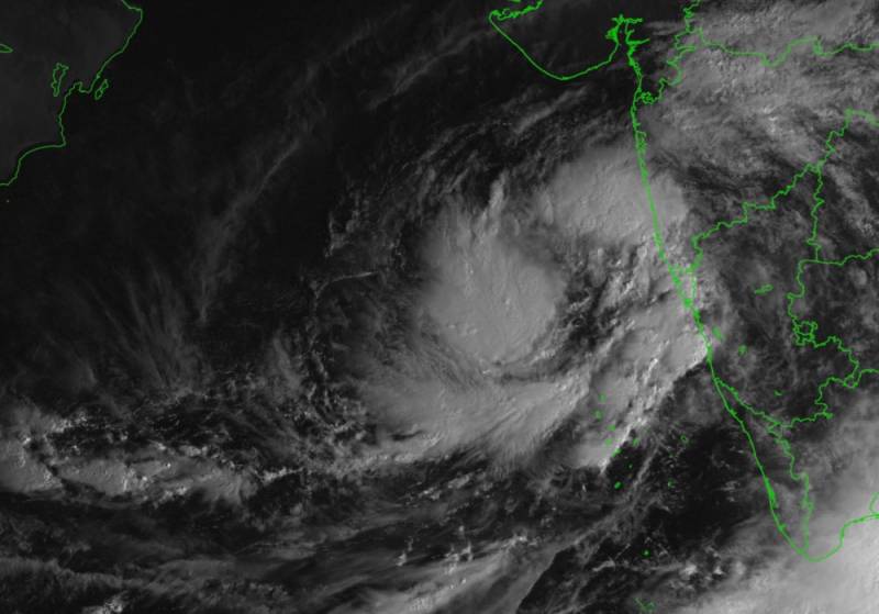
Cyclonic Storm ‘Kyarr’ over the east-central Arabian Sea
By Anusha Puppala
Hyderabad: In the past six hours, the cyclonic storm ‘Kyarr’ has moved from the east-central Arabian Sea has moved north-north-eastwards at a speed of 7 Kmph. According to the latest cyclone bulletin released by the Indian Meteorological Department (IMD). The deep depression over the Arabian Sea has intensified into a cyclonic storm in the early hours on Friday.
Kyarr cyclonic storm which lay centred at 8:30 am on Friday morning is likely to move nearly northwards in the next 12 hours and then move west-north-westwards towards Oman coast in the coming five days. It is also very likely to intensify into a severe cyclonic storm in the next 12 hours and into a very severe cyclonic storm in the subsequent 24 hours.
Light to moderate rainfall at most places with heavy to very heavy falls at isolated places is likely over coastal districts of Karnataka, Goa and south Konkan. Isolated to heavy rainfall is expected over north Konkan in the next 24 hours.
Gale wind speeds reaching 70-80 kmph gusting to 90 kmph prevail around the system centre over the east-central Arabian Sea. Wind speed is likely to increase gradually touching up to 90-100 kmph gusting to 110 kmph by the evening of October 25, and 170-180 kmph gusting to 200 kmph by the morning of October 27 over east-central and adjoining west-central the Arabian Sea around the system centre.
Wind speed reaching 55-65 kmph gusting to 75 kmph is likely to prevail along and off Ratnagiri, Sindhudurg, Raigad districts of Maharashtra and Goa. And wind speeds reaching 40 to 50 kmph gusting to 60 kmph, is expected to prevail along and off the remaining coastal districts of Maharashtra, north Karnataka coast and the north-east Arabian Sea off Gujarat coast in the next 24 hours.
Sea conditions are likely to be high to very high over the east-central Arabian Sea around the system centre in the next 24 hours and phenomenal after that. It is very likely to become phenomenal around the system centre over the west-central Arabian Sea from October 28 to the 31.
It will be very rough to high along and off Maharashtra, Goa coasts and rough to very rough along and off north Karnataka coast in the next 24 hours. It is also very likely to be rough to very rough over the north-east Arabian sea off south Gujarat coast during next 24 hours.
Some damage may occur over Ratnagiri, Sindhudurg, Raigad districts of Maharashtra and Goa. Minor damage can occur to loose and unsecured structures. Some breaches are likely to happen on Kutcha roads due to flooding, Minor damage to Banana trees and agriculture near coastal areas due to salt spray. Damage to ripe paddy crops and minor damage to Kutcha embankments may occur due to heavy rains and wind speed.
IMD has issued a warning to fisherman and advised them not to venture into along and off Maharashtra– Goa – Karnataka coasts and north-east the Arabian Sea and adjoining south Gujarat coast for the next 24 hours. The fishermen are also advised not to venture into the east-central Arabian Sea till October 28 and into the west-central Arabian Sea from October 28 to 31.