IMD forecasts heavy rains in parts of Telangana for next two days
By Newsmeter Network
Hyderabad: The Indian Meteorological Department (IMD) on Saturday preidcted heavy to very heavy rains in Adilabad, Nirmal, Mancherial, Kamareddy, Komaram Bheem, Nizamabad, Jagtial, Peddapali, Karimnagar, Rajanna Sircilla, Mahabubabad, Mulugu, Jayashankar Bhupalapalle, Warangal Urban, Warangal Rural, Bhadradri Kothagudem, Nalgonda, Suryapet and Khammam districts in Telangana for the next two days.
It also predicted light to moderate to heavy rain or thundershowers in Hyderabad for the next two days. The IMD also warned that rainwater may inundate roads in low-lying areas and urged people to restrict their movement.
A Red alert has been issued for #Telangana: Heavy to Very heavy rain with extremely heavy spells likely to occur at isolated places on 15 & 16 of August..
? NewsMeter (@NewsMeter_In) August 15, 2020
The IMD has issued the impact and action following the heavy showers. @Director_EVDM
Plan your travel accordingly. pic.twitter.com/yinbvYelaE
�
The Greater Hyderabad Municipal Corporation also warned that low to medium rainfall will continue in the city for the next 12-16 hours. They advised the citizens to stay indoors and move out only in case of emergency.
Mahesh Palawat, the head of Skymet, a private weather forecasting agency, said there will be flooding rains in many districts of Telangana for the next 48 hours.
“The rain will continue for another two days. The effect of low-pressure area over Odisha and adjoining Bay of Bengal, will be seen over Odisha, Andhra Pradesh and Telangana. Flooding rain is likely to occur for the next 48 hours over Telangana. People should avoid going outside. If it is compulsory, take all the precautions while going outside. Plan your day accordingly looking at the rain.”
�
�
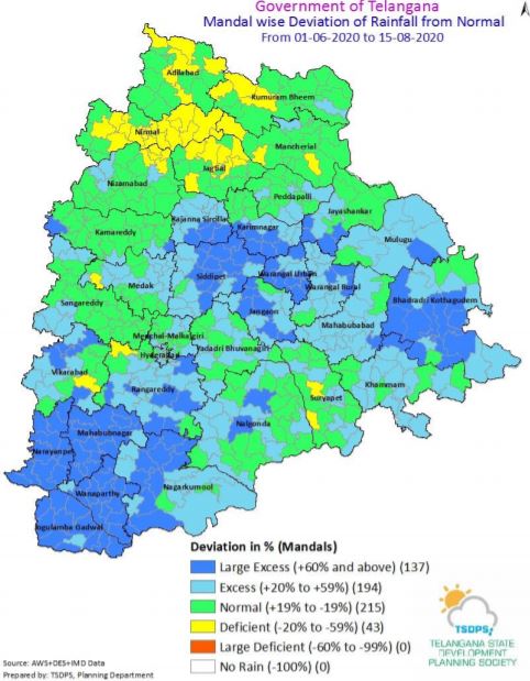
According to the Telangana State Development Planning Society, Rajendra Nagar received 34.5 mm of rain, the highest recorded in the city. Edulaggattepali in Karimnagar district received a highest rainfall of 274.8 mm in the state.
It also said that 194 mandals in the state received 20-59 per cent excess rainfall. Around 137 mandals have received more than 60 per cent rainfall while 43 mandals witnessed a deficit in rainfall.
“Now, the low-pressure area is concentrated over north Coastal Odisha & adjoining Gangetic West Bengal. Associated cyclonic circulation extends up to 7.6 km above mean sea-level tilting south westwards. It is likely to become more marked during the next 24 hours. An eastwest shear zone between 5.8 km & 7.6 km above mean sea-level runs roughly along Lat. 18°N across Peninsular India.,” read the IMD’s weather inference issued on Friday.