IMD forecasts very heavy rains in parts of Telangana for next 48 hours
By Newsmeter Network
Hyderabad: Indian Meteorological Department (IMD has forecasted heavy to very heavy rains in different parts of Telangana for the next 48 hours.
IMD said Adilabad, Nirmal, Mancherial, Komaram Bheem, Nizamabad, Jagtial, Peddapale, Karimnagar, Rajanna Sircilla, Mahabubabad, Malugu, Jayashankar Bhpalapalle, Warangal Urban, Warangal Rural, Bhadradri Kothagudem, and Khammam will receive heavy to very heavy rains in the next 48 hours.
It also predicted thunderstorm accompanied by lightning to occur at isolated places over Telangana.
IMD said light to moderate to heavy rain or thundershowers will occur in the city for the next two days. The IMD also warned that rainwater may inundate the roads in low-lying areas. It urged people to restrict their movement.
Mahesh Palwat, Vice President of Skymet, a private weather forecasting agency said the rain activities will continue today and will recede by tomorrow afternoon.
“From the afternoon of August 21, the weather will clear up. Clear weather will continue till August 24. Another spell is anticipated around August 25. However, it will not be heavy. We can say that the worst is over now. There will be an improvement in weather activities from tomorrow. Excess amount of the trough is shifting towards the south,” he said.
The low-pressure area has been formed in the Bay of Bengal and it will turn depression by today evening and moisture concentration will be much more over Odisha, Chattisgarh and Madhya Pradesh.
“It will pull the moisture from Telangana towards the side of depression which will turn the weather of Telangana into dry weather but lightening will continue. From the day after tomorrow, there will be dry weather with touchy rains,” he said.
According to the Telangana State Development Planning Society, Medapalle in Warangal rural district received the highest rainfall in the state, while Keesara in the city received 38.2 mm of rainfall, highest in the city.
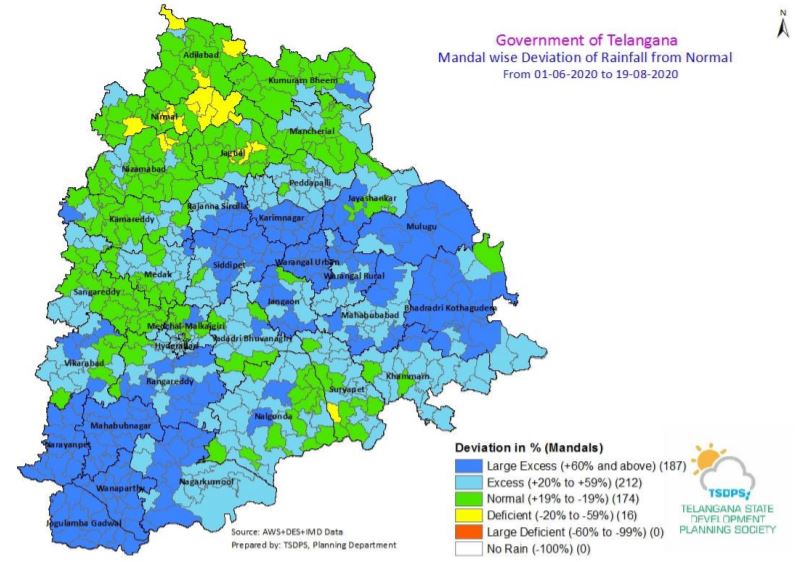
It also said that 212 mandals received excess rainfall of 20 to 59 per cent, while 187 mandals received more than 60 per cent of rainfall.
Meanwhile, 174 mandals in the state received normal rainfall and only 16 mandals saw a rainfall deficit till August 19.
“Under the influence of the cyclonic circulation over NE Bay of Bengal & neighbourhood, A low pressure has formed over North Bay of Bengal and neighbourhood at 0530 hrs IST on 19th Aug 2020 and it intensified into a Well Marked Low-Pressure Area over NW BOB and neighbourhood at 0830 hrs IST on 19th Aug2020,” read the IMD’s weather inference for Thursday.
IMD said the associated cyclonic circulation extends up to 7.6 km above mean sea level tilting southwestwards with height. “It is very likely to move westwards gradually and concentrate into a depression during the next 24 hours. The east-west shear zone now runs roughly along Lat. 21°N across central India between 3.6 km & 5.8 km above mean sea level tilting southwards with height. A fresh Low-Pressure Area is likely to develop over Northwest Bay of Bengal & neighbourhood around 23rd August 2020,” it added.