Opinion: Hyderabad Floods; Is there a solution? & answer is “big NO”
By Newsmeter Network
By Dr S. Jeevananda Reddy
We saw heated discussions on TV channels on Hyderabad floods that ceremoniously served as a post-mortem with zero outcomes. There is no solution to Hyderabad or for that matter any urban floods in India or elsewhere. Basically because it relates to five factors, namely:
• Restoration of water bodies –Encroached more than 50% wherein water holding/carrying capacity has come down drastically to less than 25%;
• Restoration of drainage/rainwater nalas – Nalas encroached partially or fully and there are no sewage facilities in several areas which has reduced water carrying capacity to less than 25%;
• Poor town planning - HMDA, HUDA, and MCH master plans created to serve vested interests, thus running rainwater recharging groundwater has come down drastically;
• Uncontrolled migration of rural population to urban areas – Nalas and water bodies have turned into living areas with the help of unscrupulous people who are collecting rents for the same;
• With the population growth, huge quantities of waste are being generated that find their way in to water bodies, nalas, etc.
Under the present votebank and real estate political syndromes and LRS2020, there is no way we can achieve these, irrespective of who is ruling at the state or the Centre.
Rainfall
Hyderabad rainfall is highly variable. As highlighted by the media, this is nothing to do with the fictitious “global warming”. Rainfall presents a natural variability. June to October the lowest to the highest average of the month in millimetres (year) are: 17.3 (1903) and 323.6 (1933); 30.5 (1899) and 365.0 (1916); 25.1 (1904) and 333.9 (1957); 32.3 (1901) and 499.4 (1908); 0.0 and 355.1 (1916).
Water bodies
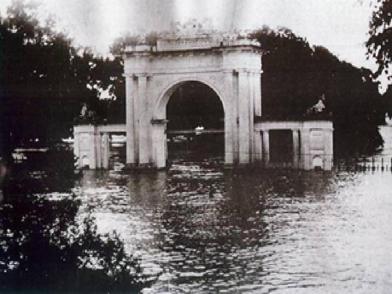 A Picture of 1908 September Floods in Hyderabad
The Mohd Quli Qutub Shaw founded Hyderabad, known as the city of lakes and gardens, on the banks of Musi river in 1591. Musi is one of the tributaries of Krishna, originating in Vikarabad’s Anantagiri Hills. Originally, river Musi was used for drinking water purpose but now it has become a cesspool of poison due to dumping of industrial and domestic waste water. In 1960 it was around 275 mld and now it is more than 2,500 mld with the population growing from 12 lakhs to 135 lakhs. Simultaneously, the riverbed lands were also encroached by more than 50 per cent. That means river Musi’s water-holding capacity has drastically reduced by more than 70 per cent. With the further rise in population, this will further come down and create a flood problem. Musi riverfront development will help vested groups but will not do anything to improve its water-holding capacity.
Bulk drug industries have been releasing chemical effluents, produced due to the excess production over the permitted capacity, with the tacit support from PCB into water bodies, nalas, etc.
The Nawab, on the advice of Sir Mokshagundam Visveswarayya - the legendry engineer of India, built Himayatsagar and Osmansagar reservoirs on Musi and its tributary Easi to contain floods and to provide drinking water to the twin cities after the September 1908 floods. Figure 1 shows the Musi floods at the present Koti Women’s College. The terrain of the city helped free flow of water that led to a nearby lake/tank and the government of Nawab built chained tanks that provided drinking and irrigation water. A majority of them are finally joining Musi river. Thus, no floods were observed in other parts of the city.
These two reservoirs - Himayatsagar and Osmansagar - have a supply capacity of around 85 mcm, which was just sufficient for a population of 12.5 lakhs in 1961. With this, the free flow of rainwater to Musi reduced drastically. However, this was countered by waste water generated by bringing huge quantity of water from faraway places like Krishna and Godavari rivers. To this was added the waste water generated by the use of groundwater to meet the growing population needs.
In 2001, a water conservation committee was formed in the Hyderabad district collectors office with the collector as convenor after the 2000 floods. I was a member along with Prof. Naidu on whose name the Supreme Court order on GO111 holds. I was assigned to present ways of recharging groundwater (at a meeting held on 24 April 2001 at HMWS &SS Conference hall). I looked into harvesting of rainwater from rooftops, recharging borewells, recharging structures (APPCB) and harvesting of rainwater through tanks/lakes (on the surface). Finally, I proposed to protect the tanks/waterbodies to provide groundwater re-charge efficiently/effectively and provide protection from floods.
According to the Environment Act, the layouts must implement creating a pond in which rainwater and treated sewage water (STPs) must be stored. This will improve the groundwater recharge and help develop greenbelts that create healthy atmosphere around the area as well as reduce the burden on the drainage system and nalas that can prevent flooding. The government has not been enthusiastic in implementing such a system. I remember a case (APPCB-CFE Committee member), a builder approached APPCB for permission to discharge the drainage water from his venture in to Fox Sagar (199.71 ha).
On the request of Metro Water Works, Hyderabad NRSA has taken up monitoring of waterbodies using multi date satellite data. Two periods of satellite data, namely December 1975 and December 2000, were used for the study. In HUDA area, they identified 932 tanks spread over 22, 623.31 ha with 173 tanks having more than 10 ha – a huge map depicting these 932 lakes were submitted to the metro water board.
HUDA brought out a notification, ‘Save Lakes for a Better Future’, dated 4 May 2000 covering 169 large lakes with more than 10 ha for getting funds from outside agencies (nobody knows where such money has gone). It states that “the entire areas falling within the full tank level of the lakes as per the Survey of India Maps, must be kept free from any types of constructions irrespective of ownership or any land use or master/zonal development plans that may have been previously notified. In addition, a buffer belt of 30 meters width on all sides of each lake must be kept free from any type of construction in the interest of prevention of pollution of lake waters and to allow free flow of water to the lakes.” It also says, “All local bodies: municipalities and gram panchayats, in whose jurisdiction these lakes fall are hereby directed to take steps to exercise utmost vigilance to prevent any type of encroachment, reclamation, pollution, or damage of any type to the lakes listed in the notification. They are also directed not to grant any permission for buildings or structures of any type within the full tank level and within the 30 meter buffer belt around the lakes under any circumstances.” Nobody has cared to implement these. More than 50 per cent of 22,623.31 ha were encroached. Also, with the modern trend by vested groups to mint thousands of crores during festivals, the lakes have started filling with waste, reducing the water-holding capacity.
Hussainsagar lake, built in 1561 and spread over 5,000 acres (2,000 ha), was reduced to 548.32 ha by 2000. The lake used to provide water for drinking and irrigation. Now, it has reduced to around 300 ha due to commercial activities undertaken by the government around the lake to serve vested interests. We filed several PILs in AP High Court to protect the lake but even the judiciary was in favour of the government’s actions. Also, the lake’s depth has reduced by more than 40 per cent and thus the water-holding capacity has come down drastically to below 25 per cent of the original capacity. This is the scenario even with the flood water reaching as high as the second floor in Ashok Nagar in September 2000.
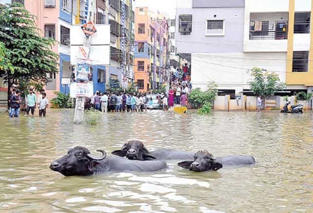 Hyderabad floods in September 2016
With reference to a PIL in the Telangana High Court, the government submitted to the court, “It is clear that the new layout regularization scheme (LRS) does not accord any blanket permission to the competent authority to regularize all illegal layouts, the government informed the HC it will not regularise layouts within full tank level (FTL) of water bodies and also those that come up on sikam land. --- the restrictions contained in GO111 in respect of constructions within the catchment area as of Osmansagar and Himayatsagar reservoirs would continue to be applicable.” It also said that “if layouts have come up in such areas, the water bodies and their courses should be maintained as recreational, buffer, and green zones and no development activity would be allowed in such areas”. This is manipulation of the LRS. You can see what is happening around Hussainsagar in violation of APPCB’s consent. In the case of Durgam Cheruvu [26.23 ha], following our PIL, the AP High Court directed the government to demolish all illegal structures. No action was taken but now the present government has encroached on the lake for commercial purposes (See Figure 2 ).
In the case of GO111, after the Supreme Court order of 2000 upholding GO111 under the Environment Act and putting “precautionary principle” [few days back Supreme Court referred this with reference a case]. In violation of all these, the AP High Court supported government actions in violation. With reference to our PIL in AP High Court (W.P.No. 9386/2007, dated 02-02-2010 government issued a Memo No. 14046/I1/07 dated 12-10-2007) wherein it stated that “---- not to allow any construction, layout and non-agriculture development activity within the upstream area of Himayatsagar and Osmansagar lakes ---”. In the case of Osmansagar lake, all land below the level of 1781 will be permanently acquired. The area at this level is 5,004 acres and in the case of Himayatsagar it is 4,816 acres at water spread at plus 1761 and water spread at plus 1765 is 5561 acres and for which money was sanctioned to acquire the land permanently.
However, to serve the vested interests the government is bent on destroying the lakes under the disguise of recreational activities that help in minting money like resorts established illegally in the catchment. I tried to stop the police department from adapting these two lakes but the irrigation department, a most corrupt department, is bent on going ahead. Also, with our PIL, the government submitted to the court that it would form a Lake Protection Authority but instead established a corrupt Lake Protection Committee (G.O.Ms.No.157 dated 06-04-2010). Also, the court did a favour by treating drainage from illegal ventures in the catchment area through STP can release the same in to lakes. Nowhere in the world is STP-treated water allowed to enter drinking water source.
Nalas & drainage system
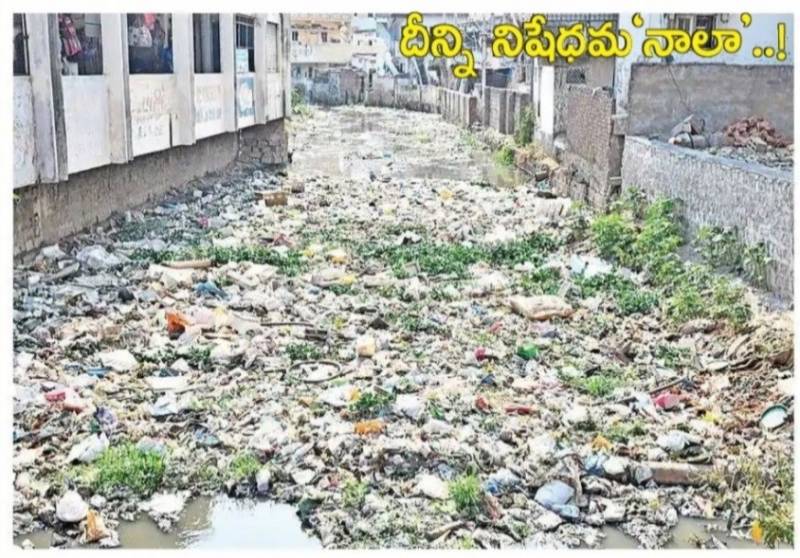 Nala Choking with the Plastic Waste in Hyderabad [Lingampalli to BHEL]
The Nawab government developed excellent drainage system to meet the population of around 12 lakhs. The new drainage is insufficient to meet the growing population which at present stands at 135 lakhs. Several layouts have no drainage system – for example the High Tech City/Madhapur. Nalas/drainage lines have been the main targets for dumping several- types of wastes (See Figure 3). This reduces the water carrying capacity of even the meagre existing nalas/drainage lines. Nalas that carry rainwater (rivulets) used to be wide and deep. You can see one a few meters away from the TRS office, the nala that carries rainwater from KBR Park to Hussainsagar Lake. Either side of this wide Nala has completely encroached. Practically, the capacities of these nalas have come down to less than 20 per cent their original capacity.
Poor quality Town Planning
Poor town planning — HMDA, HUDA, and MCH master plans created to serve vested interests, thus running rainwater recharging groundwater has come down drastically due to roads and concrete structures. In this process, many parks have been destroyed.
Dr. S. Jeevananda Reddy is the convenor of the Forum for a Sustainable Environment.