Opinion : India flexes muscle against Chinese transgression
By Newsmeter Network
By Lt General Dr. Mohan Bhandari (retired)
India, after abrogating Article 370 is no longer sitting idle as Dragon is flexing its muscles by attempting to encroach beyond LAC through repeated transgressions with particular reference to Ladakh region. India rightly has become offensive .The old mindset has changed. India shall fight, if required!
End of 1948 brought the end of Kuomintang & Chiang Kai Shek. On March 25,1949, the Central Committee of CCP & General HQ of PLA moved to Peking under the chairmanship of Mao. Except vegetating on the remote little evidence of earlier contacts left over by history, there was no connect between India & China. The year, 1950, saw Chinese invasion of Tibet & the Sino-Indian conviviality came to an end with the Tibetan rising of 1959 & giving asylum to Dalai Lama.
By October, 1962, people witnessed naked aggression of India by China wrecking the misplaced PANCHSHEEL & Bangdung spirits.
Indo-Tibetan Boundary
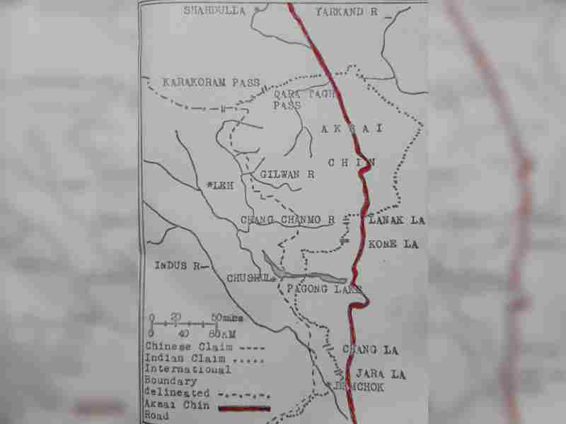
WESTERN SECTOR: Extending from Karakoram Pass to Aksai Chin Area, around 36 Degrees North, 80 Degrees East down to Shipki La at a place where Sutlej river enters into Himachal Pradesh.
CENTRAL SECTOR: This extends from Shipki La Pass to Lipu Lekh near Indo-Tibet-Nepal Trijunction.
EASTERN SECTOR: From Sikkim-Nepal-Tibet Trijunction passing over North Bhutan Border to the entire stretch of the Mc Mahon Line to Indo-Myanmar -Tibet Trijunction East of Rima.
Remaining confined to the western sector, it is pertinent to mention that Huang Ta Chen - a Chinese official had handed over a map to then British Council of Kashgar in 1893 that clearly showed Aksai Chin & Linzi Tang as parts of India. Eminent explorers, historians & travellers such as Desiderin (1715), Fraser(1820), Gumghan (1854), Nain Singh (1873), Carey (1885-87), Brown (1891), Wellby (1898) & Deasey (1900) had supported this map & other documents/evidences.
This showed the de facto & dejure sovereignty of India over her territorial limits. The areas of Demchok, Western Pagong & the Valleys of Chang Chenmo, Galwan River & Changlung Lungpa presently disputed by China were clearly shown in Indian territorial limits. India thus has firm roots in tradition, custom & treaties concluded between Ladakh & Tibet in 1684 on one hand & Tibet & China on the other - duly ratified by respective governments. The frontier now claimed by India is reflected in the Survey Map of India of 1865. (Survey conducted by WH Johnson, an officer of Survey of India)
In view of the aforesaid, it is bizarre and absurd for the Chinese to claim the area of Aksai Chin & Liz Tang & deep into the Indian territory inside Ladakh boundary between 78 Degrees East & 79 Degrees East passing South of Demchok ! Is it NOT DADAGIRI ?
All this is a blatant magnitude of Dragon’s Cartographic Invasion commencing from 1950 onwards with bringing out of rabbits with astonishing regularity ever since !
In 1962, Chinese Aggression saw the PLA advancing further south & consolidating from Demchok to Rezang La-West of Spangur - Siri Jap ,Kongka La along river valley to West of Chip Chap joining the indo-Sinkiang Border.
India has laid claim on the Watershed Principle & produced maps of British War Office published by Trigonometrical Survey of India in 1866. The Indo-Tibet Treaty of 1684 is explicit regarding Indian claims.
Indian documentary proof stands testimony that Kashmir exercised authority over Hunza from as early as 1869.
It would thus be clear that there is no basis or substance in the Chinese claim in western sector. It is purely an after-effect of the forward policy of the Chinese that became so evident during the Sino-Indian Talks of 1960. More than 20 Rounds of Border talks between India & China have taken place so far with nothing coming out of these. Yes, some local border mechanisms & temporary confidence building measures (CBMs) were agreed upon. These too have apparently failed since it is abundantly clear now that these transgressions are approved by CCP & the lifetime President of the Yellow Race.
Connected problem is the Sino-Pak Collaboration. Pakistan had illegally handed over a part of Indian Territory to China ,ie, Shakshagm Valley tract, North of Siachen Glacier, measuring 6,993 sq kms in 1963. China has made a good highway through this area linking Pakistan & up North. China had also through NE states had created a lot of problems for India.
So, all events that have taken place since 1949 till date are indicative of the fact that the Chinese ethno-centric behavioural pattern reflects it’s double standards & conflicts of ‘ideology’ , ‘power’, ‘military’, ‘ territory’, ‘economy’ & above all a total disregard to logic and thus, to International Law.
The entire world is watching the Chinese drama as it is unfolding in the Western region. Additional Indian Army troops to match up Chinese troops are being deployed in this stand off - now 25-day-old.
India must see to it that status quo is restored in Galwan Valley, Pagong Tso & other affected areas. India is fully prepared for a long stand off-talks at military & diplomatic levels notwithstanding. This is not 62.
(Let. Gen. (Dr) Mohan Bhandari, also known as the Thinking General, was born in August 1946. A veteran of the 1971 Indo-Pak war, the general has spent a number of years combating counter-insurgency/terrorist operations in Jammu and Kashmir and various other parts of the country. In his illustrious career spanning 40 years, he commanded a Rashtriya Rifles Sector in North Kashmir, was the BGS of Chinar Corps, and the GOC of the famous Dagger Division on the LC. He has also spent many years in the Ladakh region, from Turtuk-Siachen to Chushul.
He is the proud recipient of three Presidential awards presented for his exceptional services to the nation.)