Citizen Journalism: Where and how Secunderabad Parliamentary Constituency Voted, a GIS analysis
Danam Nagender, the Congress candidate from Secunderabad Parliamentary Constituency used GIS/mapping for focused attention and strategising
By Newsmeter Network
NewsMeter has always been at the forefront of highlighting people's problems, celebrating the common person's success, and encouraging people to live their dreams. We are trying to become a bridge between the government and the people. To take this initiative forward, we are introducing a citizen journalism concept This story is part of the initiative.
Hyderabad: It is a well-known fact that in the political firmament, leaders vie with each other to get the attention of voters through different methods.
The 2024 Lok Sabha elections were no different. As leaders and contestants at national and local levels, criss crossed their constituencies with padyatras, door-to-door campaigns, corner meetings, roadshows, booth-level meetings and interactions, several unconventional methods of planning, campaigning and strategising come to the fore.
Danam Nagender’s strategy
Danam Nagender, the Congress candidate from Secunderabad Parliamentary Constituency used Geographic Information System (GIS)/mapping for focused attention and strategising.
Armed with election data from the 2019 Telangana Parliament Elections, 2023 Telangana Assembly polls and PS (polling station) data of 2024, Danam and his team mapped the booths using GIS technology.
The advantage of using GIS technology is that booth-level spatial patterns emerge. As the booths are not serially located on the ground, an Excel sheet does not allow for a proximity analysis. However, GIS mapping throws up spatial patterns and indicates ‘where’ the focus should be.
Here is data on the 2024 Secunderabad Parliamentary Constituency (PC), from columns 1 to 7.
Column 8 pertains to 2019 Secunderabad PC data and with the changed political scenario PS with INC-BRS having 50 per cent vote share have been taken into consideration and compared with the voting percentage in 2024.
Of the seven Assembly Constituencies, a reasonable assumption has been made on the basis of traditional sentiment – Amberpet and Musheeerabad (BJP), Secunderabad (BRS) and Khairatabad, Jubilee Hills, Nampally and Sanathnagar (INC).
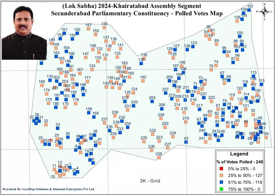
A look at a map of Khairatabad shows that there are 127 PS which have 25-50 per cent turnout and 118 PS which have 51-75 per cent turnout. The 2019 PS data indicates that 64 PS have an INC/BRS tilt. An attempt has been made to identify through a GIS overlay of these 64 PS and how they fare with the polling turnout in 2024.
Analysing polling stations
Implying that the INC+BRS PS might fare better in these 64 PS depending on the polling percentage. It is clear that in the South East Corner Grid and the South West Grid, there are large swathes of congruence, in simpler terminology common PS. This augurs well for the INC in Khairatabad.
A look at the map of Musheerabad, a BJP stronghold, shows that there are 163 PS which have a 25-50 per cent turnout and 111 PS which have a 51-75 per cent turnout. An attempt to overlay the poll turnout data with the 2019 data shows that the Central region has performed well and may contribute to increased vote share for the BJP. Musheerabad has also the highest strike rate in terms of votes/booth at 666.
The strike rates in BJP strongholds (Musheerabad at 666 and Amberpet at 612) BRS (Secunderabad at 635) INC ( Khairatabad at 614, Jubilee Hills at 536, Sanathnagar at 547 and Nampally at 548) are definite indicators as in IPL cricket.
GIS/Mapping has been conventionally used for infrastructure mapping, real estate, agriculture and other area-based activities.
For the first time perhaps, despite the role analysts, psephologists, surveys, and exit polls play, GIS mapping is being used to design/provide vital inputs to the election scenario. It’s all a question of where and as usual Hyderabad is touted as the GIS capital of the country through GIS mapping Consultants Maj (Dr) Shiva Kiran and K Venugopal show the way.
Maj (Dr) Shiva Kiran, PhD, GIS and K Venugopal, GIS and mapping consultants
Disclaimer: The views and opinions expressed in the article are those of the author and do not reflect the official policy or position of NewsMeter.