Linking road creates more problems than it solves: Nallagandla residents
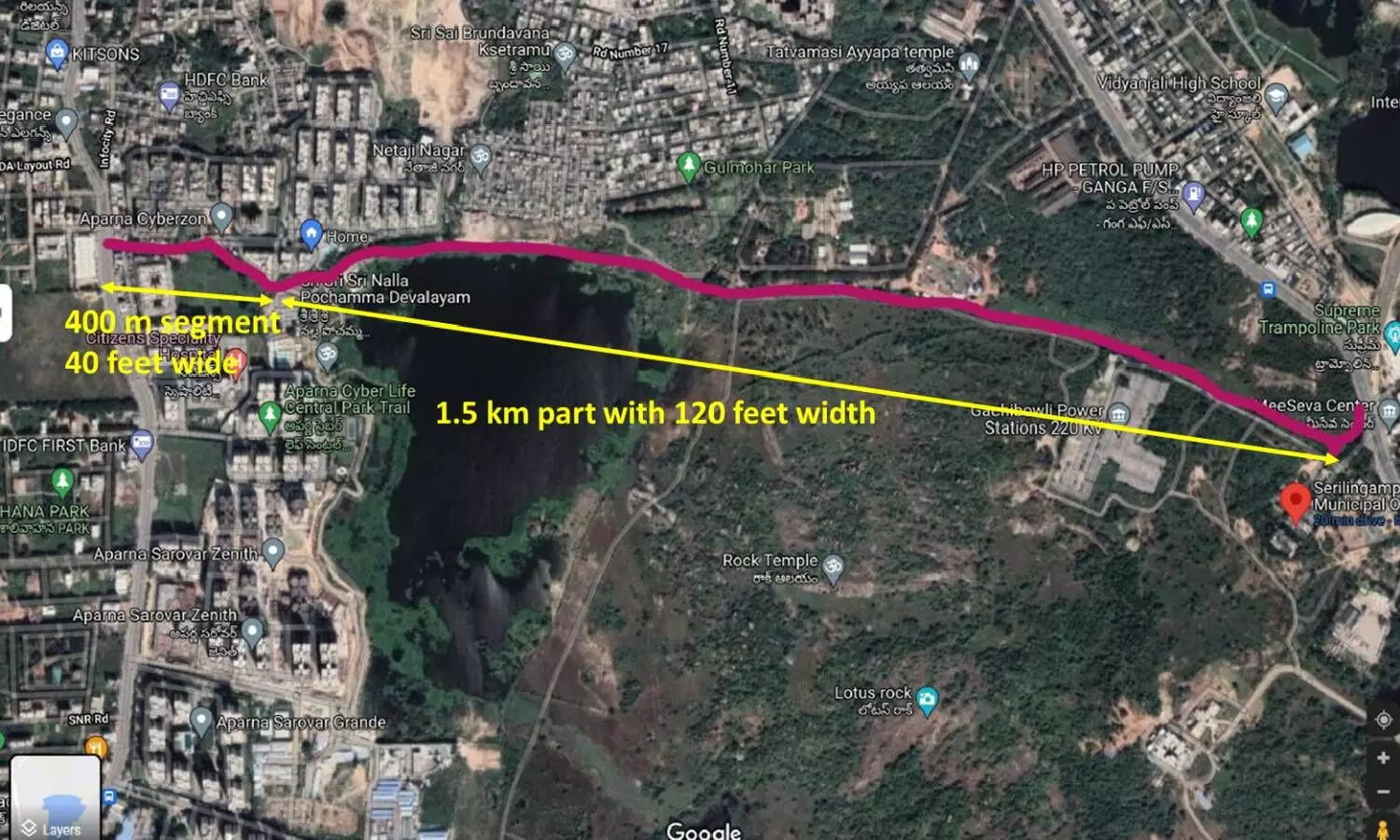
The tender notification that was recently published calls for the construction of 1.5 km long and 36 meter (120 feet) wide road between the zonal office and gated community Aparna Cyberzon. Up to Kanchi-Gachibowli road junction, there is an already existing road that would serve as the last 400-meter segment. Here's the problem: This segment is only 12 meters (40 feet) wide.
By Newsmeter Network
NewsMeter has always been at the forefront of highlighting people's problems, celebrating the common person's success, and encouraging youth to live their dreams. We are trying to become a bridge between the government and the people. To take this initiative forward, we are introducing a citizen journalism concept. Under this plan, anyone can send us stories. It can be a write-up, a video, a picture, or a narration. This story is part of the Citizen Journalism initiative.
When a linking road is not a linking road but a sinking road? When it skirts a lake that is known to overflow and reach the full tank limit. When a linking road is not a linking road but a stinking road? When it starts out as a 120 feet wide smooth road and ends in a 40 feet wide junction causing a noisy and smelly traffic bottleneck.
This is the story of the upcoming linking road in Serilingampally Mandal, along Nallagandla Lake, that would connect the GHMC zonal office with the Kanchi-Gachibowli Road at Ratnadeep junction.
GHMC and the state government are calling it a prime example of a responsive government that listens to its people and tries to make their lives easier.
However, some inconvenient facts are conveniently left out in the media blitz that has surrounded this particular road. The tender notification that was recently published calls for the construction of 1.5 km long and 36 meter (120 feet) wide road between the zonal office and gated community Aparna Cyberzon. Up to Kanchi-Gachibowli road junction, there is an already existing road that would serve as the last 400-meter segment. Here's the problem: This segment is only 12 meters (40 feet) wide. When something starts out as 120 feet and ends at 40 feet, it looks less like a well-planned strip of linking road and more like a bottle with a perfect bottleneck.
The master plan includes a wide road in the last segment as well. But given the large numbers of buildings that already exist on this patch, including a temple and residential societies, it is anyone's guess whether it will actually happen. Notably, the current tender notification is for the road up to the bottleneck. It seems that the plan is to first create the problem and then worry about it later.
Additionally, this road skirts along the boundary of Nallagandla Cheruvu, which is a beautiful mid-size lake that is home to several species of resident and migratory birds and aquatic life, and serves as a vital reservoir that keeps groundwater levels up in the entire locality. Hyderabadis are no strangers to what happens when such lakes are polluted by road construction as well as constant air and noise pollution.
In a few months, the thriving ecosystem will perish. In a few years, the groundwater will either become too polluted to use or dry up entirely, increasing the demand for expensive and eco-unfriendly water tankers. The proposed road, which is supposed to solve traffic problems at the Nallagandla flyover, will now create even more serious environmental and traffic issues at Nallgandla Lake and Ratnadeep junction.
The traffic problems are real. Commuters have to take a 2.5 km detour to get from Nallagandla to the main gate of HCU. But is this road the only available solution? There are at least two others that local citizens have proposed, but never gotten a response on. The first is a linking road that skirts the eastern and southern boundaries of the lake, with more land available outside of the full tank limit, and that connects at the Aparna Sarovar junction, which is a much wider road. This would negate the bottleneck issue, and reduce the environmental impact because of a wider buffer zone.
Planned route of the road
Another possibility is to build a road along the currently proposed route that is 40 feet wide through its entire length and to include height barriers at each end to prevent heavy vehicles from using it. Issues of the local people would be solved by each of these alternatives.
It seems that the authorities are more interested in creating the illusion of competence and responsiveness than actually doing the groundwork to solve citizen issues effectively and for the long term. Hyderabad is littered with other such examples of poor planning and government apathy masquerading as responsiveness. We hope that this time, better sense will prevail.
Beautiful Nallagandla Cheruvu that is threatened by the road
Bird life on Nallagandla Cheruvu
Migratory pelicans. Photo credit: Abhishek Pradhan
Photo credit: Abhishek Pradhan
Disclaimer: The views expressed in this article are the opinions of the author and do not represent the views of NewsMeter. We have not changed, added, or omitted anything to the text. NewsMeter is not responsible for the accuracy of the facts and the content of external links included in the article.