IMD forecast Heavy rainfall in Hyderabad for next 48 hours
By Abdul Rafeeq
Hyderabad: Indian Meteorological Department (IMD) has forecasted heavy rains likely to occur at isolated places in different parts of Telangana for the next 48 hours.
The IMD also predicted waterlogging in many parts of the low lying area in the city. They also predicted massive damage to trees and electric poles leading to disruption of transport in some areas of the city for a few hours to a few days. They also warned that drainage clogging and traffic congestion in the city.
Heavy rain very likely to occur at isolated places in districts of Sangareddy, Medak, Siddipet, Jangaon, Vikarabad, Rangareddy, Hyderabad, Medchal-Malkajgiri, Yadadri –Bhuvanagiri, Nalgonda, Suryapet, Khammam, Mahabubnagar, Nagarkurnool, Wanaparthy, Narayanpet and Jagtial will receive heavy to very heavy rains in the next 48 hours.
It also predicted thunderstorm accompanied by lightning to occur at isolated places over Telangana.
IMD said light to moderate rain or thundershowers very likely to occur in many parts at times intense spells in one or two places of the city for the next 48 hours.
The IMD also predicted waterlogging and drainage clogging in many parts of the low lying area in districts of Telangana. They also predicted massive damage to trees and electric poles leading to disruption of transport in some areas of the districts for a few hours to a few days.
According to the Telangana State Development Planning Society, During the last one day, Highest Rainfall of 208.8 mm recorded at Bhongir in Mahabubnagar district in the state, while Balapur in the city received 25.1 mm of rainfall, highest in the city.
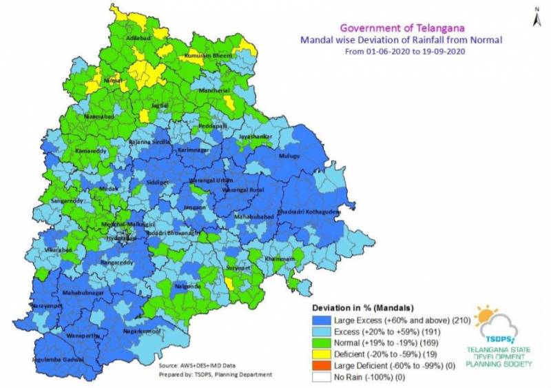
It also said that 191 mandals received excess rainfall of 20 to 59 per cent, while 210 mandals received more than 60 per cent of rainfall. Around 169 mandals in the state received normal rainfall and only 19 mandals saw a rainfall deficit till September 19.
“The east-west shear zone roughly along Lat. 16°N across Peninsular India persists and now seen between 3.1 km & 7.6 km above mean sea level tilting southwards with height. The cyclonic circulation over southwest Bay of Bengal off north Tamilnadu coast at 7.6 km above means sea level has merged with the east-west shear zone,” read the IMD’s weather inference for Saturday.
“A Low-Pressure Area is likely to develop over Northeast Bay of Bengal & neighbourhood by tomorrow, the 20th September 2020, It is likely to become more marked over Northwest Bay of Bengal & neighbourhood during subsequent 24 hours. The cyclonic circulation over Telangana & adjoining Vidarbha extending upto 0.9 km above mean sea level has become less marked.
” also stated IMD’s weather inference for Saturday.