MET forecasts heavy rains in parts of Telangana for next 5 days
By - Newsmeter Network |
Hyderabad: The Indian Meteorological Department (IMD), on October 9, predicted heavy rains in isolated places of Telangana for the next five days.
Heavy rain very likely to occur at isolated places in the districts Karimnagar, Siddipet, Jangaon, Warangal Urban, Warangal Rural, Jayashankar Bhupalapalle, Mulugu, Yadadri Bhuvanagir, Suryapet, Mahabubabad, Khammam, Bhadradri Kothagudem and Nalgonda
It also predicted thunderstorm accompanied by lightning to occur at isolated places over Telangana.
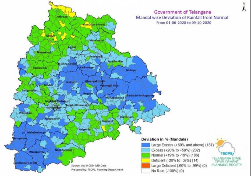
According to the Telangana State Development Planning Society, During the last one day, Highest Rainfall of 132 mm recorded at Mehdipatnam of the city in the state.
�
�
IMD said light to moderate rain or thundershowers very likely to occur in many parts of the city at times intense spells in one or two places of the city for the next 48 hours.
The IMD also predicted waterlogging and drainage clogging in many parts of the low lying area in districts of Telangana.
�
It also said that 202 mandals received excess rainfall of 20 to 59 per cent, while 187 mandals received more than 60 per cent of rainfall. Around 186 mandals in the state received normal rainfall and only 14 mandals saw a rainfall deficit till October 9.
“A low-pressure area has formed over north Andaman Sea & neighbourhood at 5:30 hrs IST of today 9th October 2020 and lies over the north Andaman Sea & adjoining East-central Bay of Bengal at 0830 hrs IST of today 9th October 2020. The associated cyclonic circulation extends upto mid tropospheric levels. It is very likely to concentrate into a depression over the central Bay of Bengal during next 24 hours. It is very likely to move west northwestwards and cross north Andhra Pradesh coast as depression during the morning of 12th October 2020,” read the IMD’s weather inference for Friday.
“The cyclonic circulation over South Coastal Andhra Pradesh & neighbourhood now lies over Rayalaseema & adjoining south Coastal Andhra Pradesh and extends up to 1.5 km above mean sea level. The trough from the cyclonic circulation over Telangana to south Tamilnadu now runs from the cyclonic circulation over Rayalaseema to south Tamil Nadu and extends upto 0.9 km above mean sea level,” also stated IMD’s weather inference for Friday.
