Heavy rains, gusty winds: Northeast India to feel Cyclone Mocha’s effects this week
From Sunday morning the mountainous regions close to India’s eastern border will see severe downpours and thunderstorms
By - Anoushka Caroline Williams |
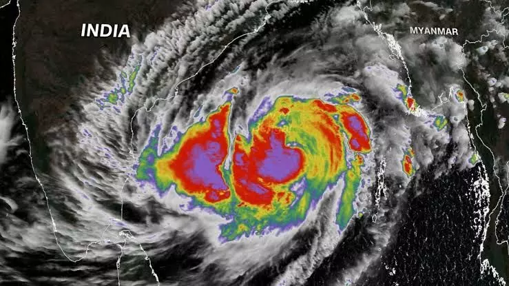
Hyderabad: Cyclone Mocha, which was earlier classified as an extremely severe cyclonic storm, has had a stunning start to the 2023 pre-monsoon cyclone season. The system, which is currently over the east-central Bay of Bengal, will reach its height in the later part of the week, with sustained wind speeds of 190-200 kmph and gusts as high as 220 kmph.
Despite this power, India hasn’t experienced any significant and immediate effects from the system this week. However, its impact on the weather in northeast India will now gradually become more noticeable and pronounced as it gets closer to the beaches of southeast Bangladesh and northern Myanmar.
The India Meteorological Department (IMD) predicts that from Saturday through the next Wednesday (13–17 May), Cyclone Mocha will provide widespread to moderately widespread mild to moderate intensity rainfall in northeast India.
From Sunday through Wednesday (14–17 May), Meghalaya will have isolated heavy rains (64.5 mm–115.5 mm), while on Sunday and Monday (14–15 May), Arunachal Pradesh will experience the same.
Additionally, Assam-Meghalaya on Monday and Tuesday (15-16 May), as well as Nagaland, Manipur, Mizoram, and Tripura from Sunday to Tuesday (14-16 May), may see scattered extremely high rainfall (115.5 mm–204 mm).
From Sunday morning through Monday afternoon, the mountainous regions close to India’s eastern border will likely see exceptionally severe downpours and thunderstorms.
Cyclone Mocha in Bangladesh and Myanmar
Cyclone Mocha, which has gusts of 210 km/h, is headed toward the Bangladesh and Myanmar coasts, according to the Bangladesh Meteorological Department (BMD). The cyclone is 490 km south-southwest of Chattogram port at midnight, 410 km south-southwest of Cox’s Bazar port, 530 km south of Mongla port, and 460 km south of Payra port.
BMD predicts it will intensify on 14 May, move in a north-northwesterly direction, and cross the coast of Cox’s Bazar-North Myanmar between 9 a.m. and 3 p.m. At midnight, the greatest sustained wind speed within 74 km of the core of the extremely severe storm was around 190 kmph, with gusts as high as 210 kmph.
The Indian Meteorological Department predicts it will pass northwestern Myanmar and southeast Bangladesh on 14 May with sustained winds of 180–190 km/h and gusts up to 210 km/h.
Aid organizations in Bangladesh and Myanmar have started establishing rescue camps. In Bangladesh, Cyclone Mocha has developed into a powerful Category 4 Atlantic hurricane with sustained winds of 240 kph (150 mph). A national cyclone early warning system is in place, and disaster response teams and more than 3,000 local volunteers have been deployed on standby. There are 7,500 emergency shelter kits, 4,000 hygiene kits, and 2,000 water containers available for distribution.