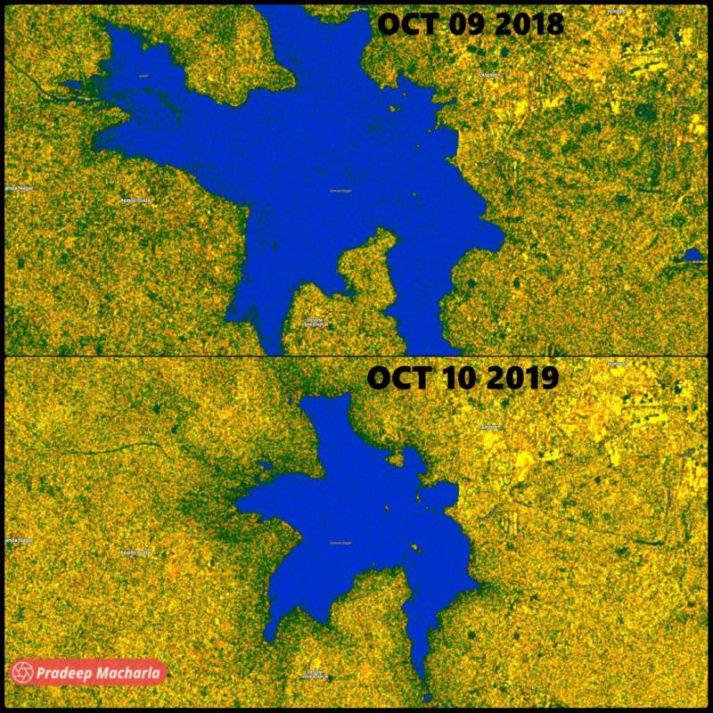
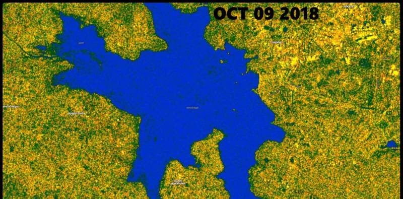
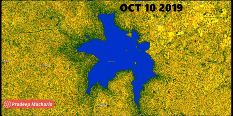
Satellite images of Hyd’s Osmansagar show reservoir receives no inflow to the lake despite heavy rains
By Dheeshma Puzhakkal
Hyderabad: Two satellite images dated 2018 and 2019 of Hyderabad’s century-old reservoir Osmansagar show how drastically the inflow has reduced despite the heavy rains. However, environmentalists and government are still on a debate, reasoning the cause for this reduced inflow.
Though monsoon was bountiful in September 2019, according to official reports, Osmansagar could supply only 88 million litres (ML) of water to Hyderabad. By October, this came down to 77 million litres.
When Hyderabad Metropolitan Water Supply and Sewerage Board (HMSWWB) faults the lack of downpour in catchment areas such as Shankarpally, Chilkur, Vikarabad, Kanapur and Himayatnagar, city environmentalists are blaming rampant encroachment for the deluge.
VL Praveen Kumar, Director Technical, HMWSSB, told NewsMeter that they are utilising 77ML water every day since October. Last month it was 88ML. The condition was better last year. This is because of a lack of rain in the reservoir’s catchment areas. Hyderabad received more than normal rainfall. However, averaging it across the entire city, some parts received rain, and some did not.”
He added that if encroachment were the reason for the lack of inflow, then water would have stagnated around those areas, and then there would be inundation. “However, we don’t hear such stories from those areas. Before monsoon, we cleared all channels to the Sagar. No encroachment or diversion of the channel came to or notice.”
Osmansagar and Himayatsagar, the twin reservoirs of Hyderabad, were made operational in 1920 and 1927 by the Nizams. Their primary purpose was to prevent flood and provide water to the city. Until the early 2000s, the reservoir offered sufficient water to the residents. However, later, encroachment disrupted the inflow channels of the tank and started to reduce its storage capacity.
Thakur Rajkumar Singh, an environmental activist, who approached the National Green Tribunal in 2016, regarding the violations of GO 111, said, “I stay 8 km away from Gandipet. Yesterday, Tuesday, the areas received 3cm rainfall. The catchment area of Osmansagar spreads over 15,000 square kilometres. Therefore, we cannot stand the argument that there is not enough downpour. You should allow water to flow into the reservoir. People are building farmhouses, resorts and gated communities on the lake’s catchment area. Water channels are redirected, and canals are broken.”
 Satellite image source: Pradeep Goud Macharla, a GIS and Remote Sensing enthusiast and Railroad Engineer, US
Satellite data source: #SAR Sentinel-1 Copernicus-EU
Another activist, Dr Lubna Sarwath, Convener of Save Our Urban Lakes (SOUL) in Hyderabad, said,” Indian meteorological data says that there was 66% excess rainfall in Ranga Reddy district. Right inside Osmansagar, there are constructions, and all the inflow channels have been blocked. They have no intention of restoring those channels and filling the Sagar. The chief minister promised people during the 2018 and 2019 election campaign that GO 111 will go away, and the price of your land will increase to crores.”
Hyderabad, which was once known as the ‘City of Lakes’, had 3,000 water bodies interconnected with Osmansagar. The city, which once had 7,000 lakes, does not have even 70 lakes today.
Currently, HMWSSB has almost stopped supplying water from the century-old reservoirs. Hyderabad’s water supply relies on Krishna and Godavari rivers. Environmentalists claim this as a strategic move to weaken the GO 111 by portraying the tanks as unnecessary.�
What is GO 111?
GO 111 is a government order that restricts development activities in the 10-km radius of Osmansagar and Himayatsagar reservoirs. The order was first brought in by the Andhra Pradesh government in 1994. Any establishment, which generates pollution in the catchment of the lakes up to 10 km from full tank level, is prohibited states the order.
 Satellite image source: Pradeep Goud Macharla, a GIS and Remote Sensing enthusiast and Railroad Engineer, US
Satellite data source: #SAR Sentinel-1 Copernicus-EU
�“We buy water for 7 rupees per litre from Krishna and Godavari. Investing crores of money, two dams were also constructed. Why can’t the authorities directly pump this water into the twin reservoirs? They will not do it; because once the reservoirs are full, many encroachments in the area will be gone. In spite of the stay on GO 111, encroachments are still happening in the catchment areas of Osmansagar and Himayatsagar,” Rajkumar said.
He continued, “From the outer-ring road if you travel towards Shamshabad airport, you will see several buildings under construction. These encroachments are bringing lakhs into government revenue. There are 84 villages around Osmansagar. If the reservoir dries more, real estate investments can pitch in. Government is not bothered about the farmers and fishermen communities who will benefit if the reservoir is full. They want to dry the reservoir and sell the land around to real estate mafia at the cost of the environment.”�
Dr C Ramachandraiah, Professor in Urban Studies (CESS), opined, “To accept the government’s claim that there was no sufficient rainfall, we need more profound studies at the ground level. Considering the vast rain, the reservoirs should be full by this time. However, it’s a known fact that the inflow channels that bring water to the twin reservoirs are obstructed or encroached by illegal constructions. Rainwater has to first fill the irrigation tanks in catchment areas and ponds on farms. From here, the fresh inflow happens towards the reservoir. However, today, we don’t have these tanks and ponds to facilitate the fresh-inflow.”
Rajkumar said that to protect water bodies, we need to stop encroachments. “Since 1930, the government has not restored a single lake in Hyderabad. Osmansagar is constructed to save Hyderabad from floods. Nature has not given any guarantee that the 1908 floods will not happen again. If a similar scenario repeats, the whole of Hyderabad will be underwater. People will die, and their properties will be damaged,” he added.
(Satellite image source: Pradeep Goud Macharla, a GIS and Remote Sensing enthusiast and Railroad Engineer, US)